Friday, May 31, 2013

Too Much Went Wrong in OKC Last Night

Yesterday, a series of storms came plowing down I-40 toward Oklahoma City. There is good reason to believe that there was at least three tornadoes from the system. (One near El Reno and Yukon, one in downtown OKC, and possibly brief, weaker tornadoes in Moore and Norman.) Five people have been confirmed dead, all in vehicles according to media reports. So what went wrong?

There were chasers all over the back roads all over this storm system. The problem turned out to be that

1. The tornadoes wound up being rain wrapped
2. There were so many chasers trying to get a good look at the tornado that they got too close

The radar image below is from when the (assumed) initial large tornado touched down near El Reno, Oklahoma (red dots are storm chasers)
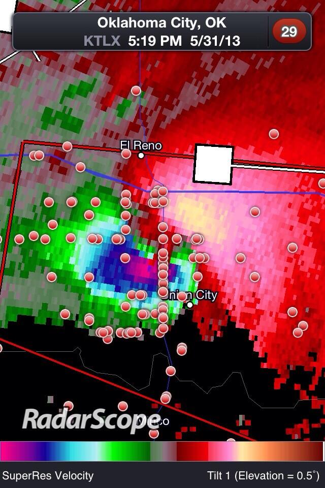
Photo courtesy Justin Hobson via Twitter
There are so many out there that were putting themselves in danger as this violent tornado rolled toward OKC. And because the tornado was not easily visible, several chasers and non-chasers got too close and things like this:
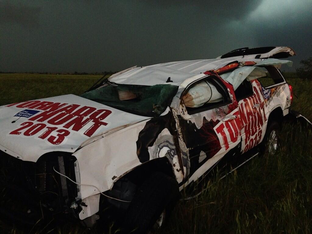
Photo courtesy Sean Schofer (TVN) via Twitter

That's what happened to the Weather Channel's chasing car. The car was thrown about 200 yards by this tornado, and how Mike Bettis didn't sustain serious injuries is beyond me. Others who drove into this were not so lucky. At least two people, a mother and her baby, died in a car when the vehicle was picked up off I-40 by the tornado and sent flying.

I'll start ranting about the chasers first.

The tornado was rain wrapped. Many of the spotters were driving through the rain to try and see this tornado, which is one of the first things I learned in spotter training. It kind of seems like one of those obvious things you shouldn't even have to think about, but look up at that radar pic again. At least 30 spotters all crowded within a couple of miles of each other, if that, trying to get a look at a tornado that really shouldn't be all that visible. It seems like after Sean Casey drove into a tornado in Kansas earlier this week, everyone got the idea to try and one-up each other by trying to get as close as they can so they can cash in on the video. And sure, we'll all be amazed by the video later, but this was basically spotters recklessly putting their lives in danger. It's not worth it. Reed Timmer, who, aside from the windows, is supposed to have one of the most "tornado proof" cars on Earth, lost the hood of his car. These tornadoes mean business.

Concerning the people in the OKC area: OK, I get it. Everyone's still freaked out after what happened in Moore last week, and Mike Morgan yet again labeled this as a "get underground, get out of its way, or you're screwed" type of tornado. But seriously?! Did we not learn anything out of last Monday?!The truth is, that's a horrible message to send to people. It incites mass panic, and that's the last thing you could possibly want or need in this situation. Below is thousands of people in vehicles trying to abandon OKC as the tornadoes approach:

Embedded image permalink
Basically the NWS'S definition of "mass panic"


In 97%+ of all cases, going to your house or wherever you are's lowest level, getting into an interior room away from windows, and if at all possible covering your head with something, regardless of if there is a basement or concrete safe room or not. For people in mobile homes, the message is clear: have a plan in place to get out of your mobile home and to a substantial shelter. That's a no-brainer, because those things get destroyed and tossed all over the place by EF1 tornadoes. But for the people who were just getting out of their safe, and in many cases, barely damaged homes, they were putting the lives of people who actually needed to get out at risk.

And then people question why the Oklahoma Highway Patrol is out trying to shut down the highways instead of letting people through to drive for their lives. They're trying to keep people from driving into the tornado, and people are thinking their just being a nuisance trying to keep people from getting out of town with their lives. Truthfully, not one other state highway patrol in the country does this to try and protect the people as far as I know (correct me if I'm wrong), and hopefully, after what's happened in OKC the last two weeks, the message will get out to people, including in OKC, where it seems like Mike Morgan calls Doomsday every time a tornado touches down within 10 miles of any city, that you shouldn't be out in the storms.

On the other hand, I see that the national media (or at least the sites I cared to look up at 1:50AM) have not gone back to the "tornado struck with no warning" crap. It's something.

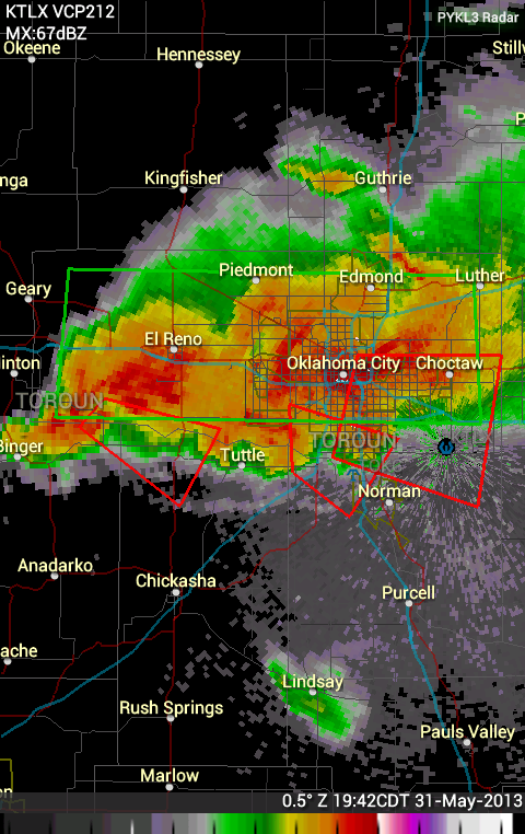


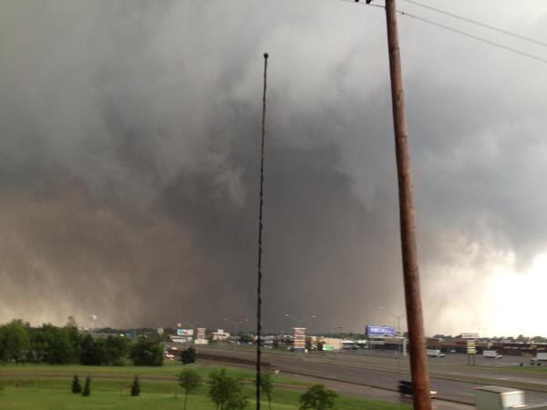


Tornado Watches #266-267

WW0266 Radar
This includes Joplin, Springfield, Cape Giradeau, Paducah, Carbondale, and Evansville.

WW0267 Radar
This includes Indianapolis, Terre Hauta, Fort Wayne, and LaFayette.

Major Tornado Outbreak Update

MONDAY: An EF4 was confirmed near Bennington, KS. Will post more later.

OKC METRO TORNADOES: At least 2 people were killed on I-40 near El Reno, Oklahoma, and it may be as high as 5. 57,000 people do not have power, last I had heard. Multiple tornadoes have occurred in the Oklahoma City area, near downtown, possibly near Moore and possible near Norman. TWC's Tornado Hunters car was picked up by the tornado, and all of the major highways in the OKC metro were parking lots as they moved through.
Embedded image permalink
And then people wonder why Oklahoma Highway Patrol is complaining that there are too many people on the road during tornadoes. This is why. They don't want ANYONE, not even Sean Casey and Reed Timmer going down the highway trying to get near the tornado, and people are just breezing by OHP like there's nothing going on while they're trying to block the highways. The TV stations in OKC (*cough*KFOR*cough) often say with these large tornadoes that you need to get underground or get out of the way, which if you're in a mobile home, is a no brainer. But that's telling the people that have above ground concrete safe rooms that they aren't safe, which is absolute insanity, as many of those shelters are able to withstand large tornadoes like the ones tonight. Traffic was literally not moving down any of the highways as the tornadoes moved right into the downtown area, which will likely lead, unfortunately, to more situations like what happened to cars last week in Moore. And the storms pretty much stalled right over downtown OKC for almost two hours straight.

ST. LOUIS TORNADOES: A Holiday Inn was reportedly hit in the St. Louis suburbs. At first, it was called a "mass casualty event", but now, KMOV says it was the Holiday Inn Express on the other side of I-70 from the Holiday Inn, and the HI was not hit by the tornado. It sounds like maybe there weren't any significant injuries at either hotel, though. The Cardinals game was called off, and there was a report of people trapped by flying debris around Busch Stadium, but that now appears to be false. Just like in OKC, flash flooding is now a major issue in St. Louis, as another line is approaching the metro from the west.

Tornado Aftermath Coverage:

St. Louis (KMOV)
OKC (KWTV)

PDS Tornado Warning: St. Louis Metro Area, MO and IL

SEVERE WEATHER STATEMENT
NATIONAL WEATHER SERVICE ST LOUIS MO
813 PM CDT FRI MAY 31 2013

ILC119-MOC183-189-510-010145-
/O.CON.KLSX.TO.W.0028.000000T0000Z-130601T0145Z/
MADISON IL-ST. CHARLES MO-ST. LOUIS MO-ST. LOUIS CITY MO-
813 PM CDT FRI MAY 31 2013

...A TORNADO WARNING REMAINS IN EFFECT FOR NORTHERN ST. LOUIS CITY...
NORTHEASTERN ST. LOUIS...NORTHEASTERN ST. CHARLES AND WESTERN MADISON
COUNTIES UNTIL 845 PM CDT...

AT 810 PM CDT...A CONFIRMED LARGE AND EXTREMELY DANGEROUS TORNADO WAS
LOCATED NEAR BRIDGETON...AND MOVING EAST AT 50 MPH.

THIS IS A PARTICULARLY DANGEROUS SITUATION.

HAZARD...DAMAGING TORNADO.

SOURCE...WEATHER SPOTTERS CONFIRMED TORNADO. DAMAGE HAS BEEN
REPORTED IN AND AROUND HARVESTER TO HOMES. NUMEROUS TREES ARE DOWNED.

IMPACT...YOU ARE IN A LIFE THREATENING SITUATION. MOBILE HOMES WILL
         BE DESTROYED. CONSIDERABLE DAMAGE TO HOMES...BUSINESSES AND
         VEHICLES IS LIKELY AND COMPLETE DESTRUCTION POSSIBLE. FLYING
         DEBRIS WILL BE DEADLY TO PEOPLE AND ANIMALS. EXPECT TREES TO
         BE UPROOTED OR SNAPPED.

LOCATIONS IMPACTED INCLUDE...
OVERLAND...LAMBERT FIELD...WOODSON TERRACE...ST. JOHN...UNIVERSITY
CITY...HAZELWOOD...BERKELEY...BEL-RIDGE...KINLOCH...FLORISSANT...COOL
VALLEY...NORMANDY...HILLSDALE...FERGUSON...NORTHWOODS...DELLWOOD...
JENNINGS...BLACK JACK...BELLEFONTAINE NEIGHBORS AND RIVERVIEW.

THIS WARNING INCLUDES CONFLUENCE STATE PARK...FIRST MISSOURI STATE
CAPITOL HISTORIC SITE AND HORSESHOE LAKE STATE PARK.

PRECAUTIONARY/PREPAREDNESS ACTIONS...

TO REPEAT...A LARGE...EXTREMELY DANGEROUS AND POTENTIALLY DEADLY
TORNADO IS ON THE GROUND. TO PROTECT YOUR LIFE...TAKE COVER NOW. MOVE
TO AN INTERIOR ROOM ON THE LOWEST FLOOR OF A STURDY BUILDING. AVOID
WINDOWS. IF IN A MOBILE HOME...A VEHICLE OR OUTDOORS...MOVE TO THE
CLOSEST SUBSTANTIAL SHELTER AND PROTECT YOURSELF FROM FLYING DEBRIS.

&&

LAT...LON 3885 9049 3900 8998 3872 8990 3864 9049
TIME...MOT...LOC 0113Z 258DEG 44KT 3877 9041

TORNADO...OBSERVED
TORNADO DAMAGE THREAT...CONSIDERABLE
HAIL...<.75IN

Goodness

There are multiple tornadic circulations around the OKC metro, with more behind them. These tornadoes have caused damage around dowtown OKC, Yukon, north Moore, and Del City.

The other problem is that ever since these storms approached OKC, all of the highways have been parking lots because the TV stations are saying "get underground or get out of the way". If you live in a mobile home, you absolutely have to get out, but if you don't, you have no reason to get in your car and get out of the way.

Embedded image permalink

TORNADO EMERGENCY CONTINUES FOR OKC METRO

Tornado Emergency remains in effect. Tornadoes continue to produce major damage in and around downtown Oklahoma City, with even more tornadic storms approaching from the west.

SEVERE WEATHER STATEMENT
NATIONAL WEATHER SERVICE NORMAN OK
733 PM CDT FRI MAY 31 2013

OKC027-109-010045-
/O.CON.KOUN.TO.W.0061.000000T0000Z-130601T0045Z/
OKLAHOMA OK-CLEVELAND OK-
733 PM CDT FRI MAY 31 2013

...A TORNADO WARNING REMAINS IN EFFECT UNTIL 745 PM CDT FOR
SOUTHWESTERN OKLAHOMA AND NORTHERN CLEVELAND COUNTIES...

AT 728 PM CDT...NATIONAL WEATHER SERVICE METEOROLOGISTS AND STORM
SPOTTERS WERE TRACKING A CONFIRMED TORNADO LOCATED
3 MILES NORTH NORTHWEST OF MOORE...MOVING EAST TO SOUTHEAST
AT 25 MPH.

...THIS IS A TORNADO EMERGENCY FOR NORTH MOORE AND VALLEY BROOK...

IN ADDITION TO A TORNADO...LARGE DESTRUCTIVE HAIL UP TO SOFTBALL SIZE
IS EXPECTED WITH THIS STORM.

LOCATIONS IMPACTED INCLUDE...
MOORE...DEL CITY AND VALLEY BROOK.

PRECAUTIONARY/PREPAREDNESS ACTIONS...

TAKE COVER NOW IN A STORM SHELTER OR AN INTERIOR ROOM OF A STURDY
BUILDING. STAY AWAY FROM DOORS AND WINDOWS.

DO NOT STOP UNDER BRIDGES OR HIGHWAY OVERPASSES. THEY WILL NOT
PROTECT YOU FROM A TORNADO.

THE TORNADO MAY BE HIDDEN BY RAIN AND VERY DIFFICULT TO SEE. DO NOT
WAIT. TAKE COVER NOW.

TORNADO EMERGENCY CONTINUES FOR OKC METRO AREA (INCLUDES DOWNTOWN OKC AND NORTH MOORE!)

Multiple vehicles, including the TWC Tornado Hunters' car, have been thrown off I-40 by this tornado. TKAE COVER IMMEDIATELY!!!!

TORNADO WARNING
OKC017-027-109-010045-
/O.NEW.KOUN.TO.W.0061.130531T2357Z-130601T0045Z/

BULLETIN - EAS ACTIVATION REQUESTED
TORNADO WARNING
NATIONAL WEATHER SERVICE NORMAN OK
657 PM CDT FRI MAY 31 2013

THE NATIONAL WEATHER SERVICE IN NORMAN HAS ISSUED A

* TORNADO WARNING FOR...
  CENTRAL OKLAHOMA COUNTY IN CENTRAL OKLAHOMA...
  NORTHWESTERN CLEVELAND COUNTY IN CENTRAL OKLAHOMA...
  EASTERN CANADIAN COUNTY IN CENTRAL OKLAHOMA...

* UNTIL 745 PM CDT

* AT 651 PM CDT...A THUNDERSTORM WITH A HISTORY OF PRODUCING STRONG
  DAMAGING TORNADOES WAS LOCATED 4 MILES SOUTHWEST OF BETHANY. A TORNADO
  MAY DEVELOP AGAIN AT ANY TIME. DOPPLER RADAR SHOWED THIS DANGEROUS
  STORM MOVING EAST TO SOUTHEAST AT 20 MPH.

THIS IS A TORNADO EMERGENCY FOR WILEY POST AIRPORT...WILL ROGERS WORLD
AIRPORT...BETHANY...DOWNTOWN OKLAHOMA CITY...AND NORTH MOORE...TAKE
IMMEDIATE TORNADO PRECAUTIONS NOW.

IN ADDITION TO A TORNADO...DANGEROUS AND EXTREMELY LARGE DESTRUCTIVE
HAIL UP TO SOFTBALL SIZE IS EXPECTED WITH THIS STORM.

* LOCATIONS IMPACTED INCLUDE...
  OKLAHOMA CITY...MOORE...DEL CITY...YUKON...BETHANY...MUSTANG...WARR
  ACRES...NICHOLS HILLS...FOREST PARK...VALLEY BROOK AND LAKE ALUMA.

PRECAUTIONARY/PREPAREDNESS ACTIONS...

TAKE COVER NOW IN A STORM SHELTER OR AN INTERIOR ROOM OF A STURDY
BUILDING. STAY AWAY FROM DOORS AND WINDOWS.

DO NOT STOP UNDER BRIDGES OR HIGHWAY OVERPASSES. THEY WILL NOT
PROTECT YOU FROM A TORNADO.

TORNADO EMERGENCY: CANADIAN AND OKLAHOMA COUNTIES, OK!!

BULLETIN - EAS ACTIVATION REQUESTED
TORNADO WARNING
NATIONAL WEATHER SERVICE NORMAN OK
628 PM CDT FRI MAY 31 2013

THE NATIONAL WEATHER SERVICE IN NORMAN HAS ISSUED A

* TORNADO WARNING FOR...
  SOUTHWESTERN OKLAHOMA COUNTY IN CENTRAL OKLAHOMA...
  SOUTHEASTERN CANADIAN COUNTY IN CENTRAL OKLAHOMA...

* UNTIL 700 PM CDT

* AT 623 PM CDT...NATIONAL WEATHER SERVICE METEOROLOGISTS AND STORM
  SPOTTERS WERE TRACKING A LARGE AND EXTREMELY DANGEROUS TORNADO 6
  MILES SOUTHEAST OF EL RENO. DOPPLER RADAR SHOWED THIS TORNADO
  MOVING EAST AT 40 MPH.

THIS IS A TORNADO EMERGENCY FOR YUKON...RICHLAND...WILEY POST
AIRPORT...BETHANY...AND THE VILLAGE...TAKE IMMEDIATE TORNADO
PRECAUTIONS NOW.

IN ADDITION TO A TORNADO...DANGEROUS AND EXTREMELY LARGE DESTRUCTIVE
HAIL UP TO SOFTBALL SIZE IS EXPECTED WITH THIS STORM.

* LOCATIONS IMPACTED INCLUDE...
  EL RENO...YUKON...BETHANY...MUSTANG...WARR ACRES AND RICHLAND.

PRECAUTIONARY/PREPAREDNESS ACTIONS...

THIS IS AN EXTREMELY DANGEROUS AND LIFE THREATENING SITUATION. IF YOU
CANNOT GET UNDERGROUND GO TO A STORM SHELTER OR AN INTERIOR ROOM OF A
STURDY BUILDING NOW.

TAKE COVER NOW IN A STORM SHELTER OR AN INTERIOR ROOM OF A STURDY
BUILDING. STAY AWAY FROM DOORS AND WINDOWS.

DO NOT STOP UNDER BRIDGES OR HIGHWAY OVERPASSES. THEY WILL NOT
PROTECT YOU FROM A TORNADO.

TORNADO EMERGENCY FOR YUKON AND BANNER, OKLAHOMA!!

This storm had been moving southeast and that would have brought it right toward Will Rogers World Airport, SW OKC, and  Moore. Now based on what I've seen, it's heading due east down I-40, and that will bring it RIGHT INTO DOWNTOWN OKLAHOMA CITY!

THIS IS A TORNADO EMERGENCY! IF YOU LIVE IN YUKON, BANNER, OR ANYWHERE IN THE OKC METRO NORTH OF NEWCASTLE AND NORMAN, YOU NEED TO TAKE COVER NOW!!!!

...A TORNADO WARNING REMAINS IN EFFECT UNTIL 700 PM CDT FOR
NORTHEASTERN GRADY AND SOUTHEASTERN CANADIAN COUNTIES...

AT 619 PM CDT...NATIONAL WEATHER SERVICE METEOROLOGISTS AND STORM
SPOTTERS WERE TRACKING A LARGE AND EXTREMELY DANGEROUS TORNADO
LOCATED 4 MILES NORTHEAST OF UNION CITY...MOVING EAST AT 35 MPH.

IN ADDITION TO A TORNADO...LARGE DESTRUCTIVE HAIL UP TO SOFTBALL SIZE
IS EXPECTED WITH THIS STORM.

LOCATIONS IMPACTED INCLUDE...
EL RENO...YUKON...MUSTANG AND UNION CITY.

PRECAUTIONARY/PREPAREDNESS ACTIONS...

THIS IS AN EXTREMELY DANGEROUS AND LIFE THREATENING SITUATION. IF YOU
CANNOT GET UNDERGROUND GO TO A STORM SHELTER OR AN INTERIOR ROOM OF A
STURDY BUILDING NOW.

TAKE COVER NOW IN A STORM SHELTER OR AN INTERIOR ROOM OF A STURDY
BUILDING. STAY AWAY FROM DOORS AND WINDOWS.

DO NOT STOP UNDER BRIDGES OR HIGHWAY OVERPASSES. THEY WILL NOT
PROTECT YOU FROM A TORNADO.

THE TORNADO MAY BE HIDDEN BY RAIN AND VERY DIFFICULT TO SEE. DO NOT
WAIT. TAKE COVER NOW.

Tornado Watch #263


This includes St. Louis and Carlinville.

WCWS Update

I did not see this earlier, but here is the press release concerning the WCWS in Oklahoma City.

OKLAHOMA CITY – The NCAA has delayed the Women’s College World Series on Friday night because of the threat of severe weather in the forecast in Oklahoma City.
The NCAA’s Division I Softball Committee said the Tennessee-Washington game would not start at 6 p.m. Central as scheduled and two hours of notice would be given before the start of the game. Oklahoma and Texas are scheduled to play after the first game is finished.
The softball committee encouraged fans to stay in a safe place because the gates at Hall of Fame Stadium will not be opened until the weather has cleared.
The National Weather Service says tornadoes, baseball-sized hail and damaging winds are likely in part of Oklahoma on Friday.
Fans need to stay in a safe place. Gates will not open until the weather has cleared.
Tournament personnel will give fans a two-hour notice regarding the time of the first pitch in order to give them adequate time to arrive at the stadium safely.
Fans may also obtain updates on the NCAA softball Facebook and Twitter platforms.

Civil Emergency Message: Hebron, North Dakota

URGENT - IMMEDIATE BROADCAST REQUESTED
CIVIL EMERGENCY MESSAGE
EMERGENCY MANAGEMENT
RELAYED BY NATIONAL WEATHER SERVICE BISMARCK ND
354 PM CDT FRI MAY 31 2013

THE FOLLOWING MESSAGE IS TRANSMITTED AT THE REQUEST OF THE MORTON
COUNTY EMERGENCY MANAGEMENT AND THE CITY OF HEBRON EMERGENCY
MANAGEMENT.

A VOLUNTARY EVACUATION HAS BEEN ISSUED FOR HOMES ON THE SOUTH
SIDE OF THE CITY OF HEBRON. THERE IS A THREAT OF WATER OVER-
TOPPING THE DAM ON THE LITTLE KNIFE RIVER THAT WOULD AFFECT THE
SOUTH SIDE OF HEBRON.

PEOPLE ARE URGED TO EVACUATE BY 9 PM CDT...AND REPORT TO HEBRON CITY
HALL. BEFORE EVACUATING...PLEASE SHUT OFF ANY NATURAL GAS LINES IN
YOUR HOME...AND PLUG ANY WATER DRAINS.

FOR MORE INFORMATION PLEASE CALL THE AUDITOR`S OFFICE AT
701-878-4600. OTHER PHONE NUMBERS THAT CAN BE UTILIZED ARE
701-595-2971 AND 701-426-8544.

PDS Tornado Watch #262

WW0262 Radar
This includes Oklahoma City, Tulsa, Norman, Moore, Broken Arrow, Stillwater, Ponca City, Ardmore, and Lawton.

THIS IS A PARTICULARLY DANGEROUS SITUATION...

   * PRIMARY THREATS INCLUDE...
     SEVERAL INTENSE TORNADOES LIKELY
     NUMEROUS VERY LARGE HAIL EVENTS TO 4 INCHES IN DIAMETER LIKELY
     NUMEROUS DAMAGING WIND GUSTS LIKELY WITH SEVERAL SIGNIFICANT
       GUSTS TO 80 MPH POSSIBLE

Very Violent Situation About to Unfold

First, we'll start with that there is two watches in effect, Tornado Watch #260 is in effect, including Columbia, Joplin, and Springfield, MO and Pittsburg and Chanute, KS.
WW0260 Radar
\A new, PDS Tornado Watch will be issued over much of Oklahoma by 21Z. A PDS Tornado Watch has not been issued for the OKC metro since May 2011.

Additionally, the SPC is considering issuing the first High Risk area of the year momentarily.

Some advice for the area of greatest concern: First, consider postponing outdoor activities after about 4:00 or so if at all possible, and if you can't make sure that there is a nearby shelter. Unfortunately, most towns don't have public shelters, but if the venue you are at has a designated shelter, go there if you fall under a warning. I know that the NCAA Softball World Series is going on in OKC as we speak, and I would hope that ASA Hall of Fame Stadium has a tornado emergency action plan, ready to activate.

Update: The SPC has not opted to go with a high risk, and will stick with the moderate risk for now. I will note though, that they bumped the hail probability in central Oklahoma to 60%, which is as high as it goes, so even if you don't get hit by a tornado, large hail is almost a guarantee. YOU HAVE TO EVEN TAKE SEVERE THUNDERSTORM WARNINGS SERIOUSLY. It doesn't get mentioned enough, but those severe non-tornadic storms can cause the same amount of damage as an EF0 to, in some extreme cases, EF2 type damage. And obviously, if they're forecasting the possibility of softball size hail, you definitely do not want to be outside.

Tornado probability:

Straight Line Wind:

Large Hail:

I'll post some good Twitter pages to follow for info, and then links for live streams in this area.

On Twitter:

Storm Prediction Center (@NWSSPC)
NWS Norman (@NWSNorman)
NWS Wichita (@NWSWichita)
Severe Studios (@SevereStudios)

There are also various chasers you can follow such as Reed Timmer (@ReedTimmerTVN), but because they will be out in the field today, they will likely put out far less information than if they weren't out.

Live Streams for local TV coverage:
KFOR-TV Oklahoma City
KJRH_TV Tulsa
KSN-TV Wichita
KOMU-TV Columbia
KFSM-TV Fort Smith


I'll post coverage for the Joplin and Springfield area TV stations if I can find it.

Thursday, May 30, 2013

Possible Large Tornado Near Broken Arrow, OK

The Tulsa TV station I'm watching, thanks to having streaming available, has not reported a lot of damage, but their spotters have reported power flashes and there has been a debris ball on radar. Very violent storm moving parallel to the Muskogee Turnpike. Take cover now!

UPDATE: Reports are of major damage on the eastern part of Broken Arrow. Watch continuing coverage here.

Via the Tulsa Terminal Radar as it passed over Broken Arrow.
Embedded image permalink

Wednesday, May 29, 2013

Civil Emergency Message: Butte County, SD

BULLETIN - EAS ACTIVATION REQUESTED
CIVIL EMERGENCY MESSAGE
BUTTE COUNTY SHERIFF IN BUTTE COUNTY SOUTH DAKOTA
ISSUED BY NATIONAL WEATHER SERVICE RAPID CITY SD
835 PM MDT WED MAY 29 2013

THE FOLLOWING MESSAGE IS BEING TRANSMITTED AT THE REQUEST OF BUTTE
COUNTY SHERIFF.

FLASH FLOODING HAS OCCURRED OVER MANY LOCATIONS ACROSS BUTTE COUNTY.
THE SHERIFF RECOMMENDS NO TRAVEL ON ANY ROADS THAT ARE COVERED WITH
WATER.

ALL OTHERS SHOULD AVOID THIS AREA. FOLLOW THE INSTRUCTIONS
OF YOUR LOCAL EMERGENCY MANAGEMENT OR LAW ENFORCEMENT OFFICIALS.

STAY TUNED TO A LOCAL RADIO OR TV STATIONS FOR FURTHER INFORMATION.

IF YOU ARE IN AN EMERGENCY SITUATION AND FURTHER INFORMATION IS
NEEDED...YOU CAN CONTACT BUTTE COUNTY DISPATCH AT 605-892-2737

Tornado Watch #245

WW0245 Radar
This includes Abilene, San Angelo, Wichita Falls, and Sanderson.

My Storm Log #2: Frustration

This is why I hate having a very limited budget and amount of time to be able to storm chase. Everything's just gone crazy this week down in Kansas and Nebraska, and I'm stuck here. The major tornado outbreak for Minnesota? Not materializing. Isolated severe threat for the area overnight.

The valid Day 2 convective outlook sounds a bit more promising.

...ERN DAKOTAS INTO THE UPPER GREAT LAKES...

   SIGNIFICANT MID LEVEL SHORT-WAVE TROUGH IS EXPECTED TO EXTEND FROM
   MID LEVEL LOW...SEWD ACROSS SERN SD INTO CNTRL IA BY 31/00Z.  DEEP
   LAYER SHEAR WILL INCREASE ACROSS THIS REGION SUCH THAT ANY STORMS
   THAT EVOLVE COULD ROTATE...POSSIBLY ATTAINING SUPERCELL
   CHARACTERISTICS.  MUCH OF THE MID MS VALLEY/UPPER GREAT LAKES WILL
   STRUGGLE TO DESTABILIZE APPRECIABLY DUE TO EXTENSIVE CLOUD COVER. 
   HOWEVER STRONG BOUNDARY LAYER HEATING WILL BE NOTED ACROSS NEB INTO
   SERN SD.  STRONG/SEVERE TSTMS WILL LIKELY BE ONGOING AT THE
   BEGINNING OF THE PERIOD ALONG NOSE OF LLJ AND THIS ACTIVITY SHOULD
   PROPAGATE/DEVELOP NEWD IN ASSOCIATION WITH THE LLJ INTO SRN WI
   DURING THE AFTERNOON HOURS.

And that's why. 

Tornado Watch #244

WW0244 Probability
Oh boy, this one includes Moore. Also includes OKC, Ardmore, the western suburbs of Tulsa, Stillwater, and Ponca City.

Tornado Watch #243

WW0243 Radar
This includes Manhattan, Concordia, and Lincoln.


Today's Severe Threat

The SPC issued a moderate risk area for parts of Kansas, Oklahoma, and Texas for the possibility of storms this afternoon and evening. There could be even more tornadoes around the OKC area today, which is the last thing anyone cleaning up in Moore need. Around that, there is a very large slight risk extending almost border to border from Texas to the Dakotas.

Tornado:

Straight Line Wind:

Hail:

This needs to be taken deadly serious today. The SPC hasn't used the 15% tornado probability this year as far as I can remember, which is what the SPC defines as warranting a moderate risk. We'll see if they bump it up to a high risk later today, but it's probably not going to happen.

From Monday: Sean Casey (of IMAX and "Storm Chasers" fame) drove into another tornado in Kansas.

Monday, May 27, 2013

Tornado Watch #231

WW0231 Radar
This includes Lincoln, McCook, Salina, and Hill City.

Severe Thunderstorm Watch #230

WW0230 Probability
This includes Sanderson, Midland, San Angelo, and Childress.

Severe Thunderstorm Watch #229

WW0229 Radar
This includes St. Louis, Champaign, Decatur, Lafayette, and Terre Haute.

Severe Thunderstorm Watch #228 (Further Severe Weather Discussion, Too)

WW0228 Radar
This includes Goodland, Scottsbluff, and Sidney.

Getting to the severe weather discussion: we'll start with the SPC saying that there is at least some chance of severe storms in the northern and central Plains through Thursday, with a moderate risk in place for today. Significant tornadoes are possible over parts of Kansas and Nebraska, mainly between I-70 and I-80 west of Omaha and Kansas City.

The rest of the week has caught everyone's eye, especially Wednesday night through Friday, where there could be some very significant severe weather in the northern Plains. I've heard some people throw out the possibility of a major tornado outbreak in Minnesota towards the end of this week. It's still too far out to tell what exactly the system will do, but it does bear watching. I have great interest in this, and if the storms come to Minnesota with a fury, you'll probably see a chase log post on here some time next weekend.

Just thought I'd throw that out there while I could. Have a good Memorial Day.

Severe Thunderstorm Watch #227

WW0227 Radar
This includes Miles City, Gillette, Rapid City, and Mobridge.

Sunday, May 26, 2013

Severe Thunderstorm Watch #224

WW0224 Radar
This includes Omaha, Lincoln, Grand Island, and Norfolk.

Tornado Watch #223

WW0223 Radar
This includes Grand Island, Norfolk, and Kearney.

Severe Thunderstorm Watch #222

WW0222 Radar
This includes Lewiston, Billings, Gillete, and Miles City.

Saturday, May 25, 2013

Flash Flood Emergency: San Antonio

BULLETIN - EAS ACTIVATION REQUESTED
FLASH FLOOD WARNING
NATIONAL WEATHER SERVICE AUSTIN/SAN ANTONIO TX
1228 PM CDT SAT MAY 25 2013

THE NATIONAL WEATHER SERVICE IN AUSTIN SAN ANTONIO HAS EXTENDED THE

* FLASH FLOOD WARNING FOR...
  BEXAR COUNTY...

* UNTIL 330 PM CDT.

* AT 1227 PM CDT...NATIONAL WEATHER SERVICE METEOROLOGISTS HAVE
  ASSESSED THAT WIDESPREAD AND LIFE THREATENING FLOODING WILL
  CONTINUE ACROSS THE SAN ANTONIO METRO AREA EARLY THIS AFTERNOON.
  RECENT DOPPLER RADAR ESTIMATES SUGGEST THAT AN ADDITIONAL 1/2
  TO 1 INCH OF RAINFALL IS POSSIBLE THROUGH 2 PM CDT. THIS RAIN
  WILL COMBINE WITH EARLIER RAINS OF UP TO 15 INCHES TO PRODUCE
  ADDITIONAL FLASH FLOODING. DOZENS OF HIGH WATER RESCUES AND
  FLOODED HOMES HAVE ALREADY BEEN REPORTED...AND SOME OF THE
  LARGER STREAMS IN BEXAR COUNTY MAY CONTINUE TO RISE...OR REMAIN
  AT EXTRAORDINARY OR NEAR RECORD LEVELS.

  THIS IS A FLASH FLOOD EMERGENCY FOR THE CITY OF SAN ANTONIO. THIS
  IS A LIFE THREATENING SITUATION.

* SOME LOCATIONS THAT WILL EXPERIENCE FLOODING INCLUDE...SAN
  ANTONIO...ALAMO HEIGHTS...CHINA GROVE...CROSS MOUNTAIN...
  ELMENDORF...HELOTES...HOLLYWOOD PARK...KIRBY...LACKLAND AFB...LEON
  SPRINGS...LEON VALLEY...LIVE OAK...OLMOS PARK...SEA WORLD...SHAVANO
  PARK...SOMERSET...TERRELL HILLS...THE DOMINION...TIMBERWOOD PARK
  AND WINDCREST.

PRECAUTIONARY/PREPAREDNESS ACTIONS...

WHEN WATER COVERS THE ROAD...TURN AROUND DON`T DROWN. THE LIFE YOU
SAVE MAY BE YOUR OWN.

Many water rescues have been happening in San Antonio today, and I apologize for not posting this sooner. 

Friday, May 24, 2013

Tornado Outbreak Wrap-Up Part 2

I completely forgot to mention more of the tornadoes during the first Tornado Outbreak Wrap-Up, so I'll try and put some new information.

First off: in Oklahoma, the Shawnee tornado was rated an EF4, and the Edmond tornado was rated an EF3. See NWS Norman's page about it for more information on Sunday, and also see here for tornado track info from them.

I might have mentioned that the Rozel, KS EF4 briefly for the stat about violent tornadoes happening on 3 straight days, but NWS Dodge City did go and do a damage survey. Surprisingly, they did not get any reports of injuries or fatalities, so that is just absolutely amazing considering the strength of the storm.


Severe Thunderstorm Watch #215

WW0215 Initial Radar image
This includes Goodland, Garden City, and Imperial.

Wednesday, May 22, 2013

Tornado Outbreak Wrap-Up

The tornado outbreak will go down with the first and (likely and hopefully) only EF5 tornado of the year, the first time an EF4 or EF5 tornado has happened on three consecutive days since June 7-9, 1953 (Yes, even 4/25-28 didn't have that happen), and, sadly, the deadliest tornado event of the year, bumping the tornado death toll for the year from something close to 5 up to around 30. (Previous high was the Kemper County, MS EF3 that killed 2.

The TV stations in Oklahoma City did a brilliant job of warning people, with all of the stations in town providing non-stop information. All of those guys deserve a big thank you for warning the public. (Go to Youtube and look up "moore tornado coverage" if you didn't get to see the live video via TV or Internet and you want to.)

Some of the things we learned/re-learned from the outbreak:

1. The warning system worked brilliantly, with 16 minutes of warning before the tornado touched down, and 30 before it hit Moore. In hindsight, as bad as 24 dead is (which is 24 too many), it could've been a lot worse. I woke up Tuesday and saw a report that it may be as high as 91, which would've been a top 25 deadliest tornado if it were true.

2. The national media *cough* CNN *cough* will never stop saying "there was no warning" in exchange for a "better" story. They will also not stop saying "the sirens saved almost everyone" or "we need more sirens". A great Google+ post by James Spann was made earlier about the sirens, who, if anyone knows anything about him knows, has had enough of this "siren mentality" crap for a long time, especially after 4/27/11 and 1/23/12.

3. Moore, Shawnee, and all of the other areas who were hit by tornadoes this past weekend will rebuild. Many who have lived here for a long time have rebuilt and come back stronger multiple times, and there is no doubt in my mind that these communities will rebuild and come back stronger, just as they have before.

Fewer Storms Today, 2 Year Anniversary of the Joplin Tornado

TODAY'S SEVERE: For the first time since Friday, the severe weather risk has moved out of the Central Plains, and there isn't a moderate risk in place. The greatest threat for severe weather will be from the Tennessee Valley up to the Great Lakes, with the greatest tornado potential being over Ohio.


REMEMBERING JOPLIN: On this day two years ago, a large violent tornado ripped across Joplin, Missouri. The tornado touched down on the western side of the city, and destroyed much of the southern side of Joplin, killing 158, the 7th deadliest all time.
picture

This article from Reuters sheds a little more light on the fear Joplin residents had Monday when the sirens went off shortly after the Moore tornado.


Tuesday, May 21, 2013

Moore Tornado Officially Rated EF5

The NWS office in Norman sent a survey team out to look at the damage that happened in Moore yesterday, and they concluded the same thing everyone has assumed since damage pictures began to come in to local media outlets: The Moore tornado was an EF5, the first and likely only EF5 tornado of the year. If there's any good news, the death toll went down greatly, from 51 to 24, which includes 9 kids found in Plaza Towers Elementary School. From NWS Norman:


You've seen the video and images already, and if you want to help, there are ways you can. The city of Moore has already started turning away volunteers because they've got enough, but many places in the OKC area, and even well outside of OKC, are taking donations of food, water, and clothing. You can donate $10 to the Red Cross at redcross.org, or text REDCROSS to 90999.

If you've been listening to the national media, at some point, you've probably heard them say that there was no warning, which is about as far from the truth as you could be. The Tornado Warning went out 16 minutes before there even was a tornado on the ground, and 30 minutes before it actually hit Moore. The Tornado Emergency went out at 3:00 and reiterated it at least two other times as the tornado hovered over the city of Moore.

And if you're the religious type, pray for the people of Moore. Keep the superintendent of the Moore schools in your thoughts too, because if what happened after the Enterprise, Alabama EF4 in 2007 happens again, the national media will go down to Moore, humiliate him for not letting school out early for the rest of the week, and leave with a "good" story, and his nerves, even if his house wasn't hit (I'm not sure if it was) will be as frayed as everyone else's down there.


Tornado Watch #207

WW0207 Radar
This includes Memphis, Jackson, Dyersburg, Jonesboro, Tupelo, Greenville, and Columbus AFB.

Monday, May 20, 2013

Severe Thunderstorm Watch #196

WW0196 Initial Radar image
This includes Chicago, Rockford, Milwaukee, Madison, LaCrosse, Dubuque, and Wisconsin Dells.

Tornado Watch #195

WW0195 Probability
This includes Ardmore, McAlester, Fort Smith, the northern suburbs of Little Rock, Springfield, and

Tornado Disaster Tonight in Moore

Today has just been unbelievable. The state medical examiner's office has confirmed that 37 people have died. It is not known if this includes all of the 24 or more people who were trapped in Plaza Towers Elementary School. Many places have opened up as shelters, including some housing areas on the University of Oklahoma campus. 

To donate $10 to tornado relief, text REDCROSS to 90999.

Some looting has been reported near Moore Medical Center, but the National Guard is getting that under control. 

Fortunately, as it stands, there have been far fewer tornadoes since then, but a large area of severe weather will continue throughout the night. More severe wind and hail are likely, and isolated tornadoes are still a possibility, and subsequently, several Tornado and Severe Thunderstorm Watches remain in effect until later tonight. For Moore and the OKC area as a whole, the severe weather threat has wound down greatly, but people here still need to be aware. Severe weather will continue near places like Fort Smith, St. Louis, Columbia, and Tulsa.
Valid WW Image

Tornado Watch #193

WW0193 Radar
This includes St. Louis, Columbia, and Springfield.

The images coming out of Moore are sickening. I'll post more updates later.

Speaking of tornadoes in populated areas:

1. The tornado that hit Wichita yesterday was an EF1.
2. This storm could head up toward the Dallas area, including, unfortunately, Cleburne.
Embedded image permalink

Emergency Situation in Moore, OK

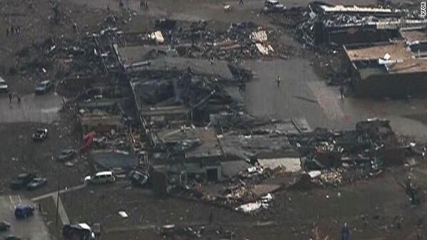
You probably saw the tornado emergency post earlier for Moore and South Oklahoma City. Unfortunately, that tornado did stay on the ground, and went right through Moore. The tornado at one point may have been two miles wide. Two elementary schools in Moore took direct hits, and at least 75 people were trapped at Plaza Towers Elementary, and 30 have been pulled out alive. KWTV is reporting multiple fatalities. KFOR is calling this "possibly the worst tornado in history" and called it "May 3rd, 1999 all over again". I'll let you be the judge of whether or not it was the worst ever.
Embedded image permalink

Embedded image permalink

Embedded image permalink
Please stay out of the Moore area. If you live near Moore or south OKC and can use your Twitter account, use #OKHaves if you have something to assist with, or #OKNeeds if you are in need of something.

Mike Morgan of KFOR said that he's never seen anything this bad, and he was working there during the May 3rd tornado. I'll post more info on how to donate to help the disaster area soon. NWS Norman have given this tornado a very preliminary EF4 rating, but likely will be upgraded to an EF5 once the weather calms down and NWS Norman can send a full survey team through the Moore area.


TORNADO EMERGENCY FOR MOORE AND SOUTH OKC, OKLAHOMA


TORNADO WARNING
OKC027-087-109-202045-
/O.NEW.KOUN.TO.W.0026.130520T2001Z-130520T2045Z/

BULLETIN - EAS ACTIVATION REQUESTED
TORNADO WARNING
NATIONAL WEATHER SERVICE NORMAN OK
301 PM CDT MON MAY 20 2013

THE NATIONAL WEATHER SERVICE IN NORMAN HAS ISSUED A

* TORNADO WARNING FOR...
  NORTHWESTERN MCCLAIN COUNTY IN CENTRAL OKLAHOMA...
  SOUTHERN OKLAHOMA COUNTY IN CENTRAL OKLAHOMA...
  NORTHERN CLEVELAND COUNTY IN CENTRAL OKLAHOMA...

* UNTIL 345 PM CDT

* AT 259 PM CDT...NATIONAL WEATHER SERVICE METEOROLOGISTS AND STORM
  SPOTTERS WERE TRACKING A LARGE AND EXTREMELY DANGEROUS TORNADO NEAR
  NEWCASTLE. DOPPLER RADAR SHOWED THIS TORNADO MOVING NORTHEAST AT 20
  MPH.

THIS IS A TORNADO EMERGENCY FOR MOORE AND SOUTH OKLAHOMA CITY.

IN ADDITION TO A TORNADO...LARGE DESTRUCTIVE HAIL UP TO TENNIS BALL
SIZE IS EXPECTED WITH THIS STORM.

* LOCATIONS IMPACTED INCLUDE...
  MIDWEST CITY...MOORE...NEWCASTLE...STANLEY DRAPER LAKE...TINKER AIR
  FORCE BASE AND VALLEY BROOK.

PRECAUTIONARY/PREPAREDNESS ACTIONS...

THIS IS AN EXTREMELY DANGEROUS AND LIFE THREATENING SITUATION. IF YOU
CANNOT GET UNDERGROUND GO TO A STORM SHELTER OR AN INTERIOR ROOM OF A
STURDY BUILDING NOW.

TAKE COVER NOW IN A STORM SHELTER OR AN INTERIOR ROOM OF A STURDY
BUILDING. STAY AWAY FROM DOORS AND WINDOWS.

Sunday, May 19, 2013

Tornado Watch #187

WW0187 Radar
This includes Cedar Rapids, Dubuque, Moline, Peoria, Rockford, Madison, La Crosse, and Rochester.

TORNADO EMERGENCY: WICHITA KANSAS


SEVERE WEATHER STATEMENT
NATIONAL WEATHER SERVICE WICHITA KS
ISSUED BY NATIONAL WEATHER SERVICE TOPEKA KS
347 PM CDT SUN MAY 19 2013

KSC173-192115-
/O.CON.KICT.TO.W.0007.000000T0000Z-130519T2115Z/
SEDGWICK-
347 PM CDT SUN MAY 19 2013

...A TORNADO WARNING REMAINS IN EFFECT FOR SOUTHERN SEDGWICK COUNTY
UNTIL 415 PM CDT...

...TORNADO EMERGENCY FOR WICHITA...

AT 345 PM CDT...A CONFIRMED LARGE...VIOLENT AND EXTREMELY DANGEROUS
TORNADO WAS LOCATED ON THE SOUTHWEST SIDE OF WICHITA...AND MOVING
NORTHEAST AT 30 MPH.

THIS IS A PARTICULARLY DANGEROUS SITUATION.

HAZARD...DEADLY TORNADO.

SOURCE...WEATHER SPOTTERS CONFIRMED TORNADO.

IMPACT...YOU COULD BE KILLED IF NOT UNDERGROUND OR IN A TORNADO
         SHELTER. COMPLETE DESTRUCTION OF NEIGHBORHOODS...BUSINESSES
         AND VEHICLES WILL OCCUR. FLYING DEBRIS WILL BE DEADLY TO
         PEOPLE AND ANIMALS.

LOCATIONS IMPACTED INCLUDE...
MAIZE...DOWNTOWN WICHITA...WICHITA...BEL AIRE...MCCONNELL AIR FORC...
EAST WICHITA AND OAKLAWN.

PRECAUTIONARY/PREPAREDNESS ACTIONS...

THIS IS AN EXTREMELY DANGEROUS TORNADO WITH COMPLETE DEVASTATION
LIKELY. YOU COULD BE KILLED IF NOT UNDERGROUND OR IN A TORNADO
SHELTER. DO NOT DELAY...SEEK SHELTER NOW! IF NO UNDERGROUND SHELTER
IS AVAILABLE SEEK SHELTER IN AN INTERIOR ROOM OF THE LOWEST LEVEL OF
A STRUCTURE...OR IF TIME ALLOWS...CONSIDER MOVING TO AN UNDERGROUND
SHELTER ELSEWHERE. MOBILE HOMES AND OUTBUILDINGS WILL OFFER NO
SHELTER FROM THIS TORNADO.

&&

LAT...LON 3748 9773 3778 9751 3779 9715 3765 9715
      3748 9743
TIME...MOT...LOC 2047Z 233DEG 27KT 3765 9738

TORNADO...OBSERVED
TORNADO DAMAGE THREAT...CATASTROPHIC
HAIL...2.75IN

I should note that NWS Topeka issued this due to NWS Wichita, at the Wichita airport, took shelter.

Tornado Watch #183

WW0183 Radar
This includes Council Bluffs, Des Moines, Cedar Rapids, and Moline.

Tornado Watches #180-182

WW0180 Radar
This includes Minneapolis, Rochester, Waterloo, Mason City, and St. Cloud.
WW0181 Radar
This includes Kansas City, St. Joseph, Wichita, Salina, and Lincoln.
WW0182 Radar
This includes Ardmore, Norman, Oklahoma City, Vance AFB, and Tulsa.