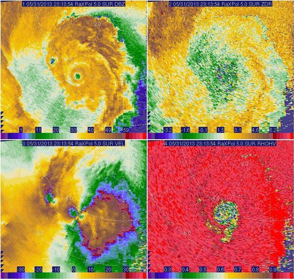
Based on velocity data from the research mobile radar used by OU scientists, the El Reno tornado was upgraded to an EF5. The actual damage appears to have been EF3, so it was very lucky that this tornado didn't actually hit any towns, or the destruction would be mind boggling. Which also brings up the question of are we actually going to rate this tornado based on radar velocity data and not the actual damage? The area where the tornado most likely would've caused EF5 damage was hopefully (and likely) out over open country. And unlike the Moore tornado where they determined that the debris ball was 2+ miles wide, the actual tornado was 2.6 miles wide, which I believe sets some sort of new record. (The previous record I believe was the Hallam, NE EF4 of 2004, which was nearly 2.5 miles wide.) Unbelievable.
Summary from NWS Norman is below...
PUBLIC INFORMATION STATEMENT
NATIONAL WEATHER SERVICE NORMAN OK
1206 PM CDT TUE JUN 4 2013

...UPDATE ON MAY 31 EL RENO TORNADO...

METEOROLOGISTS WITH THE NATIONAL WEATHER SERVICE AND RESEARCHERS FROM
THE UNIVERSITY OF OKLAHOMA CONTINUE TO INVESTIGATE INFORMATION
RELATED TO THE MAY 31 EL RENO TORNADO.

WITH THIS INVESTIGATION... THE TORNADO HAS BEEN UPGRADED TO AN EF5
TORNADO BASED ON VELOCITY DATA FROM THE RESEARCH MOBILE RADAR DATA
FROM THE UNIVERSITY OF OKLAHOMA RAXPOL RADAR. IN ADDITION... THE
WIDTH OF TORNADO WAS MEASURED BY THE MOBILE RADAR DATA TO BE 2.6
MILES AFTER THE TORNADO PASSED EAST OF US HIGHWAY 81 SOUTH OF EL
RENO. THIS WIDTH IS THE WIDTH OF THE TORNADO ITSELF AND DOES NOT
INCLUDE THE DAMAGING STRAIGHT-LINE WINDS NEAR THE TORNADO AS
DETERMINED BY THE HIGH-RESOLUTION MOBILE RADAR DATA. THE 2.6 MILE
TORNADO PATH WIDTH IS BELIEVED TO BE THE WIDEST TORNADO ON RECORD
IN THE UNITED STATES.

.EL RENO TORNADO

RATING:                  EF5
PATH LENGTH /STATUTE/:   16.2 MILES
PATH WIDTH /MAXIMUM/:    2.6 MILES
FATALITIES:              N/A
INJURIES:                N/A

START DATE:              MAY 31 2013
START TIME:              6:03 PM CDT
START LOCATION:          8.3 WSW OF EL RENO /CANADIAN COUNTY /OK
                           NEAR COURTNEY ROAD ABOUT 1 MILE NORTH
                           OF REUTER ROAD
START LAT/LON:           35.495 / -98.095

END DATE:                MAY 31 2013
END TIME:                6:43 PM CDT
END LOCATION:            6.2 ESE OF EL RENO /CANADIAN COUNTY /OK
                           NEAR INTERSTATE 40 AND BANNER ROAD
END LAT/LON:             35.502 / -97.848

$$

SMITH/GARFIELD/SPEHEGER/AUSTIN
The weather service also determined that EF1 tornadoes hit Lightning Creek Park (OKC) and SW OKC and Will Rogers World Airport. EF0s hit SE OKC and Moore.
From the OU RaXPol Radar, which estimated that the peak winds in the El Reno tornado was about 296mph, the highest known radar recorded wind speed since the May 3, 1999 tornado. :


No comments:
Post a Comment