Wednesday, June 19, 2013

Well This Sucks

SPC's Day 2 convective outlook:


If you do follow me on Twitter (@Joshsoma), you've probably heard me complain about my trip to Denver being at the same time actual severe weather is supposed to be happening, and how I have no reason to cancel or postpone it. Long story short, I'm not going to be able to chase as I will be beginning the long drive to Denver. I have a little hope in that my first night's stop, in Pierre, SD, is on the edge of the slight risk area.

I also have some hope in that night stop #2, Mount Rushmore/Keystone, SD, is in the risk area for the Day 3 outlook.

That being said, the only way I'll probably end up in a storm is if one goes right over wherever I am at a given time. As for social media updates, my Twitter and Google+ accounts use until the end of June will be inconsistent at best, and the blog likely won't be updated at all.

So, that's it. Check for more updates (and hopefully a couple of storm pics) after I return in July.

Tuesday, June 18, 2013

Severe Thunderstorm Watch #324

WW0324 Radar
This includes Springfield, Terre Haute, the northern Louisville suburbs, and the southern Indianapolis suburbs.

THE NWS STORM PREDICTION CENTER HAS ISSUED A

   * SEVERE THUNDERSTORM WATCH FOR PORTIONS OF 
     CENTRAL AND EAST CENTRAL ILLINOIS
     PARTS OF CENTRAL AND SOUTHERN INDIANA
     EXTREME NORTHERN KENTUCKY

   * EFFECTIVE THIS TUESDAY AFTERNOON AND EVENING FROM 155 PM UNTIL
     900 PM CDT.

   * PRIMARY THREATS INCLUDE...
     SEVERAL DAMAGING WIND GUSTS TO 70 MPH POSSIBLE
     SEVERAL LARGE HAIL EVENTS TO 1.5 INCHES IN DIAMETER POSSIBLE

Thursday, June 13, 2013

Evacuation Immediate: Colorado Springs, CO

BULLETIN - EAS ACTIVATION REQUESTED
EVACUATION IMMEDIATE
COLORADO EMERGENCY MANAGEMENT AGENCY PUEBLO COLORADO
RELAYED BY NATIONAL WEATHER SERVICE PUEBLO CO
135 PM MDT THU JUN 13 2013

THE CITY OF COLORADO SPRINGS HAS ISSUED A MANDATORY EVACUATION
ORDER. THE NORTH BORDER IS NORTH GATE BOULEVARD AND OLD NORTH GATE
ROAD. THE SOUTH BORDER IS FLYING HORSE CLUB DRIVE...VINE CLIFF
HEIGHTS...EQUINOX DRIVE...SERENITY PARK DRIVE...BAROSSA VALLEY
ROAD AND VENETO WAY. THE EAST BORDER IS HIGHWAY 83 AND THE WEST
BORDER IS VOYAGER PARKWAY. A MANDATORY EVACUATION MEANS THAT YOU
ARE IN IMMEDIATE DANGER. LOAD YOUR FAMILY AND YOUR PETS INTO YOUR
VEHICLE AND LEAVE NOW. ONCE YOU HAVE LEFT THE EVACUATION ZONE YOU
WILL NOT BE ALLOWED TO RE-ENTER UNTIL THE DANGER HAS PASSED.
RESIDENTS WITH NO MEANS OF TRANSPORTATION OR WHO ARE PHYSICALLY
UNABLE TO EVACUATE ON THEIR OWN...SHOULD ASK A NEIGHBOR TO ASSIST
THEM OR CALL 7 1 9...4 4 4...7 0 0 0. RESIDENTS WHO CANNOT STAY
WITH FAMILY AND FRIENDS OUTSIDE THE EVACUATION AREA...GO TO THE
FOLLOWING SHELTER...PALMER RIDGE HIGH SCHOOL AT 19255 MONUMENT
HILL ROAD IN MONUMENT.

Severe Thunderstorm Watch #309

WW0309 Radar
This includes Riverton, Casper, Sheridan, Miles City, Billings, and Glasgow.

SEVERE THUNDERSTORM WATCH NUMBER 309
   NWS STORM PREDICTION CENTER NORMAN OK
   105 PM MDT THU JUN 13 2013

   THE NWS STORM PREDICTION CENTER HAS ISSUED A

   * SEVERE THUNDERSTORM WATCH FOR PORTIONS OF 
     EASTERN MONTANA
     CENTRAL AND NORTHERN WYOMING

   * EFFECTIVE THIS THURSDAY AFTERNOON AND EVENING FROM 105 PM UNTIL
     900 PM MDT.

   * PRIMARY THREATS INCLUDE...
     SEVERAL LARGE HAIL EVENTS WITH A FEW VERY LARGE HAIL EVENTS TO 3
       INCHES IN DIAMETER POSSIBLE
     SEVERAL DAMAGING WIND GUSTS TO 70 MPH POSSIBLE

PDS Severe Thunderstorm Watch #308

WW0308 Radar
This include Raleigh, Durham, Fayetteville, Cape Hatteras, Norfolk, Richmond, and Salisbury.

SEVERE THUNDERSTORM WATCH NUMBER 308
   NWS STORM PREDICTION CENTER NORMAN OK
   210 PM EDT THU JUN 13 2013

   THE NWS STORM PREDICTION CENTER HAS ISSUED A

   * SEVERE THUNDERSTORM WATCH FOR PORTIONS OF 
     SOUTHERN MARYLAND
     EASTERN NORTH CAROLINA
     SOUTHEAST VIRGINIA
     COASTAL WATERS

   * EFFECTIVE THIS THURSDAY AFTERNOON AND EVENING FROM 210 PM UNTIL
     1000 PM EDT.

   ...THIS IS A PARTICULARLY DANGEROUS SITUATION...

   * PRIMARY THREATS INCLUDE...
     NUMEROUS SIGNIFICANT DAMAGING WIND GUSTS TO 80 MPH LIKELY
     SEVERAL VERY LARGE HAIL EVENTS TO 3 INCHES IN DIAMETER POSSIBLE
     A FEW TORNADOES POSSIBLE

Severe Thunderstorm Watch #307

WW0307 Radar
This includes Charlotte, Asheville, Knoxville, Nashville, Chattanooga, Rome, Huntsville, and Florence.

SEVERE THUNDERSTORM WATCH NUMBER 307
   NWS STORM PREDICTION CENTER NORMAN OK
   145 PM EDT THU JUN 13 2013

   THE NWS STORM PREDICTION CENTER HAS ISSUED A

   * SEVERE THUNDERSTORM WATCH FOR PORTIONS OF 
     NORTHERN ALABAMA
     NORTHERN GEORGIA
     WESTERN NORTH CAROLINA
     NORTHWEST SOUTH CAROLINA
     MIDDLE AND EASTERN TENNESSEE

   * EFFECTIVE THIS THURSDAY AFTERNOON AND EVENING FROM 145 PM UNTIL
     800 PM EDT.

   * PRIMARY THREATS INCLUDE...
     SEVERAL SIGNIFICANT DAMAGING WIND GUSTS TO 75 MPH POSSIBLE
     SEVERAL VERY LARGE HAIL EVENTS TO 2 INCHES IN DIAMETER POSSIBLE
     A FEW TORNADOES POSSIBLE

Wednesday, June 12, 2013

PDS Severe Thunderstorm Watch #302

WW0302 Radar
This includes Cincinnati, Cleveland, Youngstown, Columbus, Pittsburgh, Morgantown, and Charleston.

SEVERE THUNDERSTORM WATCH NUMBER 302
   NWS STORM PREDICTION CENTER NORMAN OK
   1150 PM EDT WED JUN 12 2013

   THE NWS STORM PREDICTION CENTER HAS ISSUED A

   * SEVERE THUNDERSTORM WATCH FOR PORTIONS OF 
     SOUTHEAST INDIANA
     EXTREME NORTHEAST KENTUCKY
     WESTERN MARYLAND
     MUCH OF OHIO
     SOUTHWEST PENNSYLVANIA
     CENTRAL AND NORTHERN WEST VIRGINIA
     LAKE ERIE

   * EFFECTIVE THIS WEDNESDAY NIGHT AND THURSDAY MORNING FROM 1150
     PM UNTIL 600 AM EDT.

   ...THIS IS A PARTICULARLY DANGEROUS SITUATION...

   * PRIMARY THREATS INCLUDE...
     NUMEROUS SIGNIFICANT DAMAGING WIND GUSTS TO 80 MPH LIKELY
     SEVERAL LARGE HAIL EVENTS LIKELY WITH A FEW VERY LARGE HAIL
       EVENTS TO 2 INCHES IN DIAMETER POSSIBLE
     A FEW TORNADOES POSSIBLE

PDS Severe Thunderstorm Watch #300

WW0300 Radar
This includes Milwaukee, Chicago, South Bend, Gary, Detroit, Fort Wayne, and Toledo.

 SEVERE THUNDERSTORM WATCH NUMBER 300
   NWS STORM PREDICTION CENTER NORMAN OK
   400 PM CDT WED JUN 12 2013

   THE NWS STORM PREDICTION CENTER HAS ISSUED A

   * SEVERE THUNDERSTORM WATCH FOR PORTIONS OF 
     NORTHEAST ILLINOIS
     NORTHERN INDIANA
     SOUTHERN LOWER MICHIGAN
     NORTHWEST OHIO
     SOUTHEAST WISCONSIN
     LAKE ERIE
     LAKE MICHIGAN

   * EFFECTIVE THIS WEDNESDAY AFTERNOON AND THURSDAY MORNING FROM
     400 PM UNTIL 100 AM CDT.

   ...THIS IS A PARTICULARLY DANGEROUS SITUATION...

   * PRIMARY THREATS INCLUDE...
     NUMEROUS SIGNIFICANT DAMAGING WIND GUSTS TO 80 MPH LIKELY
     SEVERAL VERY LARGE HAIL EVENTS TO 2 INCHES IN DIAMETER POSSIBLE
     A FEW TORNADOES POSSIBLE

Severe Thunderstorm Watch #299

WW0299 Radar
This includes Havre, Great Falls, Helena, and Butte.

 SEVERE THUNDERSTORM WATCH NUMBER 299
   NWS STORM PREDICTION CENTER NORMAN OK
   230 PM MDT WED JUN 12 2013

   THE NWS STORM PREDICTION CENTER HAS ISSUED A

   * SEVERE THUNDERSTORM WATCH FOR PORTIONS OF 
     CENTRAL MONTANA

   * EFFECTIVE THIS WEDNESDAY AFTERNOON AND EVENING FROM 230 PM
     UNTIL 1000 PM MDT.

   * PRIMARY THREATS INCLUDE...
     SEVERAL LARGE HAIL EVENTS WITH A FEW VERY LARGE HAIL EVENTS TO 2
       INCHES IN DIAMETER POSSIBLE
     SEVERAL DAMAGING WIND GUSTS TO 70 MPH POSSIBLE

PDS Tornado Watch #298

WW0298 Radar
This includes Mason City, Waterloo, Cedar Rapids, the Quad Cities, Rockford, Madison, and Austin.

NWS STORM PREDICTION CENTER NORMAN OK
   150 PM CDT WED JUN 12 2013

   THE NWS STORM PREDICTION CENTER HAS ISSUED A

   * TORNADO WATCH FOR PORTIONS OF 
     NORTHEAST IOWA
     NORTHERN ILLINOIS
     EXTREME SOUTHEAST MINNESOTA
     SOUTHWEST WISCONSIN

   * EFFECTIVE THIS WEDNESDAY AFTERNOON AND EVENING FROM 150 PM
     UNTIL 900 PM CDT.

   ...THIS IS A PARTICULARLY DANGEROUS SITUATION...

   * PRIMARY THREATS INCLUDE...
     SEVERAL INTENSE TORNADOES LIKELY
     SEVERAL SIGNIFICANT DAMAGING WIND GUSTS TO 80 MPH POSSIBLE
     SEVERAL VERY LARGE HAIL EVENTS TO 3 INCHES IN DIAMETER POSSIBLE

FYI About Severe Weather Coverage Here

I will try and post all severe weather watches and updates. It would be better to not monitor the blog, and monitor my Google+ account (+Joshua Soma) or my Twitter (@Joshsoma) if you're going to rely on me for severe weather information, which I do not recommend. I would still recommend keeping track of info through your local TV and radio stations, as well as the Facebook and Twitter pages of your local NWS office for information. (Most NWS offices do have Facebook and Twitter accounts. List of offices in the risk area below:

Quad Cities, IA serving eastern Iowa and western Illinois
Chicago, IL serving northeast Illinois
Lincoln, IL serving central Illinois
Syracuse, IN serving northern Indiana
La Cross, WI serving southwest Wisconsin, northeast Iowa, northwest Illinois, and southeast Minnesota.
Milwaukee, WI serving southeast Wisconsin
Indianapolis, IN serving central Indiana
Grand Rapids, MI serving western Michigan
Detroit, MI serving eastern Michigan
Wilmington, OH serving southwest Ohio

I will post links to live streams and that sort of thing if I come across them.

First HIGH RISK of the Year Today

MD 1040 graphic
The Storm Prediction Center will upgrade an area of northern Illinois and northern Indiana to a High Risk of severe weather, citing 15% tornado probabilities and 60% straight line wind probabilities in the 1630z (12:30 PM EDT/11:30AM CDT) Day 1 convective outlook. Major severe weather, including some large, violent tornadoes, and later on the possibility of a major derecho. A derecho is when a line of storms causes significant wind damage over a large area of at least 240 miles. The most recent example of one was the event of June 29-30 of last year, where storms formed in a line west of Chicago, eventually converging into one large line, and causing major damage around the DC metro area, among others, during a massive heat wave. See below for the SPC discussion:

 MESOSCALE DISCUSSION 1040
   NWS STORM PREDICTION CENTER NORMAN OK
   1026 AM CDT WED JUN 12 2013

   AREAS AFFECTED...EXTREME ERN IA...NRN IL...NRN IND...NWRN OH

   CONCERNING...OUTLOOK UPGRADE 

   VALID 121526Z - 121630Z

   SUMMARY...THE 1630Z CONVECTIVE OUTLOOK WILL INCLUDE A CATEGORICAL
   UPGRADE TO HIGH RISK FOR DAMAGING WIND POTENTIAL FROM EXTREME
   EASTERN IOWA INTO NORTHERN PORTIONS OF ILLINOIS AND INDIANA...AND
   NORTHWEST PORTIONS OF OHIO. IN ADDITION...TORNADO PROBABILITIES WILL
   BE INCREASED TO 15 PERCENT OVER PORTIONS OF EXTREME EASTERN IOWA
   INTO NORTHWEST ILLINOIS.

   DISCUSSION...SVR TSTMS ARE EXPECTED TO DEVELOP THIS AFTERNOON IN THE
   VICINITY OF EASTERN IOWA/NORTHWEST ILLINOIS AND QUICKLY BECOME
   SEVERE SUPERCELLS WITH A RISK FOR TORNADOES...POSSIBLY
   SIGNIFICANT...WITH UPSCALE GROWTH INTO A FAST-MOVING AND
   FORWARD-PROPAGATING MESOSCALE CONVECTIVE SYSTEM. WIDESPREAD DAMAGING
   WINDS ARE LIKELY ACROSS THE HIGH RISK AREA...WITH SOME SIGNIFICANT
   SEVERE GUSTS POSSIBLE.

   DETAILS WILL BE FORTHCOMING IN THE 1630Z CONVECTIVE OUTLOOK.


Tuesday, June 11, 2013

Moderate Risk Today


The initial threat is going to be supercells with some tornadoes and straight line winds in western South Dakota, and then a long lived straight line wind event over southern South Dakota. The greatest threat will be along and near the I-90 corridor between Rapid City and Sioux Falls.

UPDATE: The SPC has also upgraded the risk for some of the Great Lakes states to moderate.


The main risks here will include hail and damaging winds as well.

Monday, June 10, 2013

Severe Thunderstorm Watch #295

WW0295 Radar
This includes Bowling Green, London, Knoxville, and Chattanooga.

NWS STORM PREDICTION CENTER NORMAN OK
   300 PM EDT MON JUN 10 2013

   THE NWS STORM PREDICTION CENTER HAS ISSUED A

   * SEVERE THUNDERSTORM WATCH FOR PORTIONS OF 
     SOUTHERN AND EASTERN KENTUCKY
     EASTERN TENNESSEE
     FAR WESTERN VIRGINIA

   * EFFECTIVE THIS MONDAY AFTERNOON AND EVENING FROM 300 PM UNTIL
     1100 PM EDT.

   * PRIMARY THREATS INCLUDE...
     SEVERAL LARGE HAIL EVENTS WITH A FEW VERY LARGE HAIL EVENTS TO 2
       INCHES IN DIAMETER POSSIBLE
     SEVERAL DAMAGING WIND GUSTS TO 70 MPH POSSIBLE
     A FEW TORNADOES POSSIBLE

Tornado Watch #294

WW0294 Radar
This includes Nashville, Crossville, Fayetteville, and Murfressboro.

 NWS STORM PREDICTION CENTER NORMAN OK
   155 PM CDT MON JUN 10 2013

   THE NWS STORM PREDICTION CENTER HAS ISSUED A

   * TORNADO WATCH FOR PORTIONS OF 
     MIDDLE TENNESSEE

   * EFFECTIVE THIS MONDAY AFTERNOON AND EVENING FROM 155 PM UNTIL
     900 PM CDT.

   * PRIMARY THREATS INCLUDE...
     SEVERAL TORNADOES POSSIBLE
     SEVERAL DAMAGING WIND GUSTS TO 70 MPH LIKELY
     SEVERAL LARGE HAIL EVENTS WITH A FEW VERY LARGE HAIL EVENTS TO 2
       INCHES IN DIAMETER POSSIBLE

Tornado Watch #293

WW0293 Radar
This includes Washington DC, Baltimore, Philadelphia, Dover, Lynchburg, Charlottesville, Richmond, and Elizabeth City.

NWS STORM PREDICTION CENTER NORMAN OK
   200 PM EDT MON JUN 10 2013

   THE NWS STORM PREDICTION CENTER HAS ISSUED A

   * TORNADO WATCH FOR PORTIONS OF 
     DISTRICT OF COLUMBIA
     DELAWARE
     MUCH OF MARYLAND
     NORTHERN NORTH CAROLINA
     SOUTHERN NEW JERSEY
     SOUTHEAST PENNSYLVANIA
     MUCH OF VIRGINIA
     THE EASTERN PANHANDLE OF WEST VIRGINIA
     COASTAL WATERS

   * EFFECTIVE THIS MONDAY AFTERNOON AND EVENING FROM 200 PM UNTIL
     1000 PM EDT.

   * PRIMARY THREATS INCLUDE...
     SEVERAL TORNADOES LIKELY
     NUMEROUS DAMAGING WIND GUSTS TO 70 MPH LIKELY

Tornado Watch #292

WW0292 Radar
This includes Columbia, Spartanburg, Greenville, Charlotte, Fayetteville, Raleigh, Durham, Chapel Hill, and Greensboro.

 120 PM EDT MON JUN 10 2013

   THE NWS STORM PREDICTION CENTER HAS ISSUED A

   * TORNADO WATCH FOR PORTIONS OF 
     EAST CENTRAL GEORGIA
     A LARGE PART OF NORTH CAROLINA
     A LARGE PART OF SOUTH CAROLINA

   * EFFECTIVE THIS MONDAY AFTERNOON AND EVENING FROM 120 PM UNTIL
     1000 PM EDT.

   * PRIMARY THREATS INCLUDE...
     SEVERAL TORNADOES LIKELY
     NUMEROUS DAMAGING WIND GUSTS TO 70 MPH LIKELY
     A FEW LARGE HAIL EVENTS TO 1 INCH IN DIAMETER POSSIBLE

Saturday, June 8, 2013

Severe Thunderstorm Watch #289

WW0289 Radar
This includes Omaha, Lincoln, Grand Island, Concordia, and Manhattan.

Severe Thunderstorm Watch #288

WW0288 Radar
This includes Wichita, Salina, Dodge City, Woodward, Childress, and Amarillo.

URGENT - IMMEDIATE BROADCAST REQUESTED
   SEVERE THUNDERSTORM WATCH NUMBER 288
   NWS STORM PREDICTION CENTER NORMAN OK
   330 PM CDT SAT JUN 8 2013

   THE NWS STORM PREDICTION CENTER HAS ISSUED A

   * SEVERE THUNDERSTORM WATCH FOR PORTIONS OF 
     CENTRAL AND SOUTHERN KANSAS
     WESTERN OKLAHOMA AND THE OKLAHOMA PANHANDLE
     WEST TEXAS AND THE TEXAS PANHANDLE

   * EFFECTIVE THIS SATURDAY AFTERNOON AND EVENING FROM 330 PM UNTIL
     1100 PM CDT.

   * PRIMARY THREATS INCLUDE...
     SEVERAL LARGE HAIL EVENTS LIKELY WITH A FEW VERY LARGE HAIL
       EVENTS TO 2 INCHES IN DIAMETER POSSIBLE
     SEVERAL DAMAGING WIND GUSTS TO 70 MPH LIKELY
     A FEW TORNADOES POSSIBLE

Wednesday, June 5, 2013

Tropical Storm Andrea

TC Activity
The National Hurricane Center has highlighted an area in the Gulf of Mexico south of Tallahassee and west of Tampa Bay as having a closed center of circulation, and winds were sufficient enough to give it a name, Tropical Storm Andrea. (BTW, the naming of hurricanes is standard NHC practice to keep hurricanes in both oceans organized during the peak tropical weather/hurricane season, and naming snowstorms is just the Weather Channel promoting its own crap.)

As of 11:00EDT/10:00CDT tonight, Andrea has a pressure of 1002 MB, and sustained winds of 40mph. Andrea was moving north at 6mph. Some bands of rain from Andrea are reaching the west coast and Keys areas of Florida, including one band producing waterspouts and possible tornadoes near Marathon, Florida.

This is the current track highlighted by NHC:
[Image of 3-day forecast, and coastal areas under a warning or a watch]
That would put the storm moving very quickly, making landfall somewhere between Tallahassee and Tampa Bay, and then racing up the eastern seaboard as a post-tropical system that could dump heavy rain. Eventually, the low will move back over the ocean, but will likely not redevelop into something new.

The Final Paths of the OKC Tornadoes and WeatherBrains

LocationPreliminary RatingBegin TimeEnd TimePath LengthMaximum Width
El Reno
(Southwest to Southeast of El Reno)
EF-56:03 PM CDT6:43 PM CDT16.22.6 miles
Lightning Creek Park
(Lightning Creek Park to Straka Terrace and Western Avenue)
EF-16:25 PM CDT6:35 PM CDT0.4 miles250 yards
Southwest Oklahoma City/Will Rogers World Airport
(Fairfax Lane, northwest of SW 15th & Morgan Road Intersection to Intersection of SW 56th and Blackwelder Ave.)
 EF-16:51 PM CDT 7:23 PM CDT 10.4miles 1.4 miles 
Moore
(NW 5th St. to W Main St.)
 EF-07:50 PM CDT 7:55 PM CDT0.5 miles  500 yards
 Southeast Oklahoma City
(Creekwood Terrace to Keith Dr., east of Valley Brook)
 EF-0 7:33 PM CDT7:40 PMCDT
0.4 miles 200 yards
Yes, that says 1.4 miles wide for the Will Rogers EF1. 

The NWS has confirmed that the El Reno EF5 was the largest known tornado to occur. 

And in case you missed it, here's Monday night's WeatherBrains, with guests including Rick Smith (WCM, NWS Norman), Dr. Marshall Sheperd (President of AMS), and Matt Mahler (TV Meteorologist, KWTV-TV, Oklahoma City). There is also a 2009 episode where Tim Samaras was on. You can watch the new one below, and the audio link for the Samaras episode is here

Tuesday, June 4, 2013

No Risk of Tsunami From Hawaii Earthquake

A 5.2 magnitude earthquake happened in Hawaii at 2:13PM HST. No tusnami is anticipated right now.

TSUNAMI SEISMIC INFORMATION STATEMENT NUMBER   1
NWS PACIFIC TSUNAMI WARNING CENTER EWA BEACH HI
215 PM HST TUE JUN 04 2013
 
TO - CIVIL DEFENSE IN THE STATE OF HAWAII
 
SUBJECT - LOCAL TSUNAMI INFORMATION STATEMENT
 
THIS STATEMENT IS FOR INFORMATION ONLY. NO ACTION REQUIRED.
 
AN EARTHQUAKE HAS OCCURRED WITH THESE PRELIMINARY PARAMETERS
 
   ORIGIN TIME - 0213 PM HST 04 JUN 2013
   COORDINATES - 18.9 NORTH  155.1 WEST
   LOCATION    - IN THE DEEP OCEAN SOUTHEAST OF THE BIG ISLAND
   MAGNITUDE   - 5.2
 
EVALUATION
 
 NO TSUNAMI IS EXPECTED. REPEAT. NO TSUNAMI IS EXPECTED.
 HOWEVER...SOME AREAS MAY HAVE EXPERIENCED STRONG SHAKING.
 
THIS WILL BE THE ONLY STATEMENT ISSUED FOR THIS EVENT UNLESS
ADDITIONAL DATA ARE RECEIVED.

El Reno Tornado Upgraded to an EF5

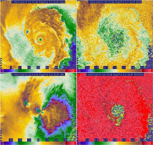
Based on velocity data from the research mobile radar used by OU scientists, the El Reno tornado was upgraded to an EF5. The actual damage appears to have been EF3, so it was very lucky that this tornado didn't actually hit any towns, or the destruction would be mind boggling. Which also brings up the question of are we actually going to rate this tornado based on radar velocity data and not the actual damage? The area where the tornado most likely would've caused EF5 damage was hopefully (and likely) out over open country. And unlike the Moore tornado where they determined that the debris ball was 2+ miles wide, the actual tornado was 2.6 miles wide, which I believe sets some sort of new record. (The previous record I believe was the Hallam, NE EF4 of 2004, which was nearly 2.5 miles wide.) Unbelievable.

Summary from NWS Norman is below...

PUBLIC INFORMATION STATEMENT
NATIONAL WEATHER SERVICE NORMAN OK 
1206 PM CDT TUE JUN 4 2013

...UPDATE ON MAY 31 EL RENO TORNADO...

METEOROLOGISTS WITH THE NATIONAL WEATHER SERVICE AND RESEARCHERS FROM 
THE UNIVERSITY OF OKLAHOMA CONTINUE TO INVESTIGATE INFORMATION 
RELATED TO THE MAY 31 EL RENO TORNADO.

WITH THIS INVESTIGATION... THE TORNADO HAS BEEN UPGRADED TO AN EF5 
TORNADO BASED ON VELOCITY DATA FROM THE RESEARCH MOBILE RADAR DATA 
FROM THE UNIVERSITY OF OKLAHOMA RAXPOL RADAR. IN ADDITION... THE 
WIDTH OF TORNADO WAS MEASURED BY THE MOBILE RADAR DATA TO BE 2.6 
MILES AFTER THE TORNADO PASSED EAST OF US HIGHWAY 81 SOUTH OF EL 
RENO. THIS WIDTH IS THE WIDTH OF THE TORNADO ITSELF AND DOES NOT 
INCLUDE THE DAMAGING STRAIGHT-LINE WINDS NEAR THE TORNADO AS 
DETERMINED BY THE HIGH-RESOLUTION MOBILE RADAR DATA. THE 2.6 MILE 
TORNADO PATH WIDTH IS BELIEVED TO BE THE WIDEST TORNADO ON RECORD 
IN THE UNITED STATES.

.EL RENO TORNADO  

RATING:                  EF5 
PATH LENGTH /STATUTE/:   16.2 MILES 
PATH WIDTH /MAXIMUM/:    2.6 MILES 
FATALITIES:              N/A 
INJURIES:                N/A

START DATE:              MAY 31 2013 
START TIME:              6:03 PM CDT 
START LOCATION:          8.3 WSW OF EL RENO /CANADIAN COUNTY /OK 
                           NEAR COURTNEY ROAD ABOUT 1 MILE NORTH
                           OF REUTER ROAD
START LAT/LON:           35.495 / -98.095

END DATE:                MAY 31 2013 
END TIME:                6:43 PM CDT 
END LOCATION:            6.2 ESE OF EL RENO /CANADIAN COUNTY /OK 
                           NEAR INTERSTATE 40 AND BANNER ROAD
END LAT/LON:             35.502 / -97.848

$$

SMITH/GARFIELD/SPEHEGER/AUSTIN

The weather service also determined that EF1 tornadoes hit Lightning Creek Park (OKC) and SW OKC and Will Rogers World Airport. EF0s hit SE OKC and Moore. 

From the OU RaXPol Radar, which estimated that the peak winds in the El Reno tornado was about 296mph, the highest known radar recorded wind speed since the May 3, 1999 tornado. :

Embedded image permalink


Monday, June 3, 2013

Civil Emergency Message/Fire Warning: Jefferson County, CO

URGENT - IMMEDIATE BROADCAST REQUESTED
CIVIL EMERGENCY MESSAGE...UPDATED
COLORADO EMERGENCY MANAGEMENT AGENCY DENVER COLORADO
RELAYED BY NATIONAL WEATHER SERVICE DENVER CO
340 PM MDT MON JUN 3 2013

THE FOLLOWING MESSAGE IS TRANSMITTED AT THE REQUEST OF THE
COLORADO EMERGENCY MANAGEMENT AGENCY DENVER COLORADO.

THIS IS JEFFERSON COUNTY SHERIFF OFFICE WE ARE WORKING A WILDLAND FIRE
IN THE AREA OF BLUEBELL CIRCLE AND BROOK FOREST DRIVE IN
EVERGREEN. WE ARE ISSUING A LEVEL 3 EVACUATION. A LEVEL 3
EVACUATION MEANS LEAVE IMMEDIATELY. DANGER IN YOUR AREA IS CURRENT
AND IMMINENT. THERE IS NO TIME TO GATHER BELONGINGS. LEAVE
IMMEDIATELY. IF YOU NEED TO GO TO A SHELTER PLEASE GO TO CONIFER
HIGH SCHOOL. IF YOU NEED HELP PLEASE CALL 911.

URGENT - IMMEDIATE BROADCAST REQUESTED
FIRE WARNING
COLORADO EMERGENCY MANAGEMENT AGENCY DENVER COLORADO
RELAYED BY NATIONAL WEATHER SERVICE DENVER CO
333 PM MDT MON JUN 3 2013

THE FOLLOWING MESSAGE IS TRANSMITTED AT THE REQUEST OF THE
COLORADO EMERGENCY MANAGEMENT AGENCY DENVER COLORADO.

THIS IS JEFFERSON COUNTY SHERIFF OFFICE WE ARE WORKING A WILDLAND FIRE
IN THE AREA OF BLUEBELL CIRCLE AND BROOK FOREST DRIVE IN
EVERGREEN. WE ARE ISSUES A LEVEL 3 EVACUATION. A LEVEL 3
EVACUATION MEANS LEAVE IMMEDIATELY. DANGER IN YOUR AREA IS CURRENT
AND IMMINENT. THERE IS NO TIME TO GATHER BELONGINGS. LEAVE
IMMEDIATELY. IF YOU NEED TO GO TO A SHELTER PLEASE GO TO CONIFER
HIGH SCHOOL. IF YOU NEED HELP PLEASE CALL 911.

Sunday, June 2, 2013

Severe Thunderstorm Watch #271


This includes Boston, Springfield, Albany, Hartford, Concord, Burlington, Portland, and Greenville.

Rest In Peace, Tim Samaras, Paul Samaras, and Carl Young

From the Twistex project's Facebook page:

This was a horrible loss for the storm chasing world. I, as many others did, looked up to these brilliant men as they pursued learning more about tornadoes and lightning to help save lives. My condolences to the families of Tim, Paul, and Carl.

Saturday, June 1, 2013

Late News and Weather Notes of the Day

BREAKING NEWS OF THE DAY: NOAA has cancelled all furloughs for the organization, including in the National Weather Service. An email was sent to staff at 11:39EDT last night from acting administrator Kathryn Sullivan. (whole email here):

WEATHERBRAINS: Maybe some of you have watched the 90 minute weekly show hosted on the Google+ hangout platform that is all about the weather, hosted by, among others, James Spann (meteorologist, ABC 33/40 in Birmingham, AL), J.B. Elliot (former Warning Coordination Meteorologist for NWS Birmingham) and Nate Johnson (meteorologist, WRAL-TV in Raleigh, NC). James announced today that this week's episode will be a two hour special starting at 9:00EDT/8:00CDT Monday night (normally a 9:30EDT/8:30CDT start every Monday), concerning the Oklahoma City tornadoes last night. The confirmed guests for this week are:

*Rick Smith, WCM for NWS Norman

*Dan McCarthy, Former WCM for the SPC

*John Brown, ABC 33/40 storm chaser (known locally for his work chasing late night and HP supercells, and as one of the best spotters in the state of Alabama)

The WeatherBrains crew has invited the following people to Monday's show, but have not heard from them as of 6:30PM CDT:

*Reed Timmer (You know, that guy who drives into tornadoes in exchange for a paycheck from KFOR and funding for "weather research" from OU and people who buy his TVN Weather T-Shirts)

*Mike Morgan, chief meteorologist at KFOR-TV in OKC, a person who has lost a lot of respect in the weather community since last night because of the traffic jams in the OKC metro last night, mainly because he and the KFOR weather team were the only ones telling people to get out of their houses and head south as the tornadoes approached, and the tornadoes turned south.

Dr. Marshall Sheperd, President of the American Meteorological Society.

The show will be live at http://live.bigbrainsmedia.com/ , and then available through iTunes, YouTube, and other podcast apps the day after the show is recorded.

IN SPORTS: In sports, the Pacers beat the Heat 91-77 to force Game 7 in Miami Monday night. The Blackhawks and Bruins both won Game 1 of their respective Conference Finals games. And Florida is up on Nebraska 9-7 in the top of the 15th inning in an NCAA Softball Championship Elimination Game. (regulation is 7) Arizona State and Michigan will not play unless they can start before 11:59PM CDT, which, with how long its already taken and with Florida threatening to blow the game open as I write, will likely not happen.
A Good Message From Tornado Titans

Via Facebook and Twitter from Tornado Titans-Extreme Weather and Storm Chasing (@TornadoTitans). He does a lot better job of expressing the weather community, and his own, frustration over the traffic mess during the OKC tornadoes yesterday than my 2AM tirade did.

A message from Tornado Titans co-founder Chris Sanner this morning: 

"So many things to say this morning, so as the personality type I am, here's a list:

1)I was not with Brandon and Brett, thank God they are ok. Brandon has apologized for their chase decisions yesterday and I believe forgiveness should be heavy on everyone's hearts but I do think key lessons were expressly learned by many chasers yesterday. No video is worth your life and getting close carries some HUGE risks. Let that be a lesson to everyone, this is a time to learn from other's mistakes to be sure.

2)I was 1.5-2 miles south and west of the tornado at all times yesterday and when it took it's southern jog I bailed south. We got blasted with the extremely strong RFD for a brief time and that in and of itself was an incredibly dangerous situation. I don't regret any personal chasing decisions but the combination of the Canadian River, erratic storm motions and....

3)...the fact OKC evacuated south made chasing impossible yesterday. I'm not sure what made KFOR think this was a good idea to recommend but I'm not going to be nice about this. That reckless comment could've cost the lives of thousands. It's criminal to go into a theater and yell fire, I think this is a similar situation. Ridiculous behavior that could've turned out much worse. I expect nothing short of an apology from that station. 

4)Nothing yesterday got us closer to being perceived as anything but reckless thrill seekers. I for one am fully in support of any and all efforts to police chasing in any way at this point. The numbers are a joke (largely have ruined chasing on the big days), and I have zero problem with any attempts to try to cut those down even if it means I have to stay at home. The fact emergency management had to respond to CHASERS instead of people who were VICTIMS is a HUGE shame. I'm sick to my stomach about that. People could have (and very well might have) died because chasers themselves chose to become victims and had to be responded to."