This includes Houston, College Station, Tyler, and Lake Charles.
Thursday, May 9, 2013
Severe Thunderstorm Watch #151
This includes Houston, College Station, Tyler, and Lake Charles.
Severe Thunderstorm Watch #150
This includes San Angelo, Abilene, and Waco.
I also note that a new Severe Thunderstorm Watch will be issued for parts of SE Texas and SW Louisiana by 4:00 CDT.
Wednesday, May 8, 2013
Update
There is a large squall line in western Kansas. It appears to be weakening a bit, but will head toward the east. Storms ahead of that are producing large hail in central Kansas, and there were some tornadoes confirmed near Hays, KS earlier. Via KSN-TV (Wichita)

In an unrelated series of storms, a brief EF0 tornado happened in Jerome County, ID.
Some storms are strengthening, while others are weakening. Just be alert for a few more hours in Kansas and Oklahoma. Spotters are also reporting some rotation near Hamilton, KS, with a storm that has been sitting there for quite some time.
KSN is on air here.
Severe Thunderstorm Watches #148-149
These include the cities of Goodland, Wichita, Oklahoma City, Lawton, and Childress.
Tuesday, May 7, 2013
Severe Thunderstorm Watch #147
This includes Woodward and Dodge City.
Saturday, May 4, 2013
Greensburg, Kansas EF5 and the May 4-6 2007 Tornado Outbreak
On this day in 2007, a tornado outbreak occurred in Kansas and Oklahoma, that produced 25 tornadoes, followed by 84 the next day, and 14 on the 6th. The tornadoes killed 14, and caused $268 million worth of damage. The outbreak is remembered for producing the Greensburg, Kansas EF5, which was the first EF5 tornado since the NWS began using the Enhanced Fujita Scale earlier that year, and the first F5/EF5 tornado since the Moore tornado from May 3, 1999.
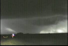
Greensburg tornado
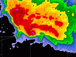
Radar signature of the tornado. Bright pink and red ball over Greensburg is the tornado debris ball.
The tornado touched down around 9:20PM southwest of Greensburg, and moved northeast. At 9:41PM, the National Weather Service in Dodge City issued a Tornado Emergency for the city, seen below.
KIOWA KS-
941 PM CDT FRI MAY 4 2007
…A TORNADO WARNING REMAINS IN EFFECT UNTIL 1000 PM CDT FOR CENTRAL KIOWA COUNTY…
…A TORNADO EMERGENCY FOR GREENSBURG….
AT 937 PM CDT…NATIONAL WEATHER SERVICE METEOROLOGISTS AND STORM SPOTTERS WERE TRACKING A LARGE AND EXTREMELY DANGEROUS TORNADO. THIS TORNADO WAS LOCATED 5 MILES SOUTH OF GREENSBURG…MOVING NORTH AT 20 MPH. A VIOLENT TORNADO WAS ON A DIRECT PATH FOR PORTIONS OF GREENSBURG…ESPECIALLY THE EASTERN PORTIONS OF TOWN. TAKE IMMEDIATE TORNADO PRECATIONS…THIS IS AN EMERGENCY SITUATION FOR GREENSBURG!!
A TORNADO WATCH REMAINS IN EFFECT UNTIL 200 AM CDT SATURDAY MORNING FOR SOUTHWESTERN KANSAS.
LAT…LON 3749 9936 3745 9929 3760 9901 3764 9936
$$
UMSCHEID
It was later determined that the tornado was 1.7 miles wide, and produced winds in excess of 205mph. The tornado was responsible for 11 of the 14 deaths in the outbreak, and two more were killed when the supercell produced another tornado that was believed to be 2 miles wide northeast of town, which was rated as an EF3.

Destruction in Greensburg
After the tornado cleanup, the city started rebuilding from scratch, and decided to rebuild green. Many of the homes in the city that are being rebuilt or have been rebuilt already are set to meet strict energy efficiency standards to help lower energy costs, and this may have helped reverse the city's trend of having a dwindling population. (Population before the tornado was about 1500.)
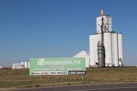
Welcome to Greensburg sign on the city limits.
Greensburg tornado
Radar signature of the tornado. Bright pink and red ball over Greensburg is the tornado debris ball.
The tornado touched down around 9:20PM southwest of Greensburg, and moved northeast. At 9:41PM, the National Weather Service in Dodge City issued a Tornado Emergency for the city, seen below.
KIOWA KS-
941 PM CDT FRI MAY 4 2007
…A TORNADO WARNING REMAINS IN EFFECT UNTIL 1000 PM CDT FOR CENTRAL KIOWA COUNTY…
…A TORNADO EMERGENCY FOR GREENSBURG….
AT 937 PM CDT…NATIONAL WEATHER SERVICE METEOROLOGISTS AND STORM SPOTTERS WERE TRACKING A LARGE AND EXTREMELY DANGEROUS TORNADO. THIS TORNADO WAS LOCATED 5 MILES SOUTH OF GREENSBURG…MOVING NORTH AT 20 MPH. A VIOLENT TORNADO WAS ON A DIRECT PATH FOR PORTIONS OF GREENSBURG…ESPECIALLY THE EASTERN PORTIONS OF TOWN. TAKE IMMEDIATE TORNADO PRECATIONS…THIS IS AN EMERGENCY SITUATION FOR GREENSBURG!!
A TORNADO WATCH REMAINS IN EFFECT UNTIL 200 AM CDT SATURDAY MORNING FOR SOUTHWESTERN KANSAS.
LAT…LON 3749 9936 3745 9929 3760 9901 3764 9936
$$
UMSCHEID
It was later determined that the tornado was 1.7 miles wide, and produced winds in excess of 205mph. The tornado was responsible for 11 of the 14 deaths in the outbreak, and two more were killed when the supercell produced another tornado that was believed to be 2 miles wide northeast of town, which was rated as an EF3.
Destruction in Greensburg
After the tornado cleanup, the city started rebuilding from scratch, and decided to rebuild green. Many of the homes in the city that are being rebuilt or have been rebuilt already are set to meet strict energy efficiency standards to help lower energy costs, and this may have helped reverse the city's trend of having a dwindling population. (Population before the tornado was about 1500.)
Welcome to Greensburg sign on the city limits.
Friday, May 3, 2013
May 3, 1999 Tornado Outbreak
On this day in 1999, a swarm of tornadoes formed over Kansas and Oklahoma, producing 70 tornadoes, killing more than 40 people. This produced the Moore, Oklahoma F5 tornado, and re-sparked the hiding under a highway overpass debate, which has long since ended, and is generally not recommended. At least two people died as a result of trying to take shelter under an overpass. KOCO, KFOR, and KWTV in Oklahoma City all did wall-to-wall coverage until early on May 4, as other major tornadoes hit places such as Dover, Mulhall, and Stroud, Oklahoma.

The Moore tornado was the first single tornado to cause $1 billion in damages. This was also the first time the National Weather Service used the term "Tornado Emergency" in a statement.
...TORNADO EMERGENCY IN SOUTH OKLAHOMA CITY METRO AREA... AT 6:57 PM CDT...A LARGE TORNADO WAS MOVING ALONG INTERSTATE 44 WEST OF NEWCASTLE. ON ITS PRESENT PATH...THIS LARGE DAMAGING TORNADO WILL ENTER SOUTHWEST SECTIONS OF THE OKLAHOMA CITY METRO AREA BETWEEN 7:15 AND 7:30 PM. PERSONS IN MOORE AND SOUTH OKLAHOMA CITY SHOULD TAKE IMMEDIATE TORNADO PRECAUTIONS! THIS IS AN EXTREMELY DANGEROUS AND LIFE THREATENING SITUATION. IF YOU ARE IN THE PATH OF THIS LARGE AND DESTRUCTIVE TORNADO...TAKE COVER IMMEDIATELY. DOPPLER RADAR HAS INDICATED THIS STORM MAY CONTAIN DESTRUCTIVE HAIL TO THE SIZE OF BASEBALLS...OR LARGER.
Subscribe to:
Posts (Atom)